• CFN has a new look and a new theme

    "I bore you on eagle's wings, and brought you to Myself" (Exodus 19:4)

    More new themes will be coming in the future!

  • Desire to be a vessel of honor unto the Lord Jesus Christ?

    Join For His Glory for a discussion on how

    https://christianforums.net/threads/a-vessel-of-honor.110278/

  • CFN welcomes new contributing members!

    Please welcome Roberto and Julia to our family

    Blessings in Christ, and hope you stay awhile!

  • Have questions about the Christian faith?

    Come ask us what's on your mind in Questions and Answers

    https://christianforums.net/forums/questions-and-answers/

  • Read the Gospel of our Lord Jesus Christ?

    Read through this brief blog, and receive eternal salvation as the free gift of God

    /blog/the-gospel

  • Taking the time to pray? Christ is the answer in times of need

    https://christianforums.net/threads/psalm-70-1-save-me-o-god-lord-help-me-now.108509/

  • Focus on the Family

    Strengthening families through biblical principles.

    Focus on the Family addresses the use of biblical principles in parenting and marriage to strengthen the family.

[_ Old Earth _] Lake Suigetsu vs a recent global deluge

jwu

Member
Joined
Oct 14, 2004
Messages
1,234
Reaction score
0
Let's just look at the proposed date of the global deluge, roughly 4000 years ago.

This is a different version of the famous lake suigetsu graph:
nature05214-f1.2.jpg


These are the actual annual layers:
suigetsucore.jpg

We *know* that these are annual because they form annually today, and there is no disruption in their pattern. Moreover, an analysis of the pollen in them also shows the passing of seasons during the sedimentation, so it is safe beyond reasonable doubt that they actually are annual layers. Radiometric dating further supports this.


So, how do creationists explain these ~40.000 layers which each represent one year according to all available evidence? Contrary to that evidence, they would have to have formed in about 4000 years, at ten times the rate which is indicated by evidence.
 
We *know* that these are annual because they form annually today
Just like we "know: ice layers = hundreds of thousands of years, and tree rings = annual growth.

i know your wrong, but i will research and get back to this.
 
johnmuise said:
We *know* that these are annual because they form annually today
Just like we "know: ice layers = hundreds of thousands of years, and tree rings = annual growth.
The sarcasm is noted...but we actually do know this for specific species and locations.

Just because some tree species in some locations do not produce annual rings doesn't mean that no tree species does. Same about ice layers - these are formed by patterns of the annual precipitation, just like "rain period and dry period" in the tropics. In places where there is no such pattern, the layers of course are not annual - but that's for known reasons and has no bearing on the "annuality" of layers where there is a stable pattern of precipitation.

Moreover, annual layers can be distinguished from non-annual ones by careful analysis.


i know your wrong, but i will research and get back to this.
You're already starting with the conclusion?
methods.gif
 
Well, there is a pretty good hypothesis about abiogenesis, and the fossil record, albeit incomplete, is far from a question mark:
hominids2.jpg

The full image...there are two skulls cut off on the right by the forum:
http://www.talkorigins.org/faqs/comdesc ... inids2.jpg

But that's a topic for another thread of course.
 
moving on..

Those are NOT annual layers. Each one represents an inundation;
several of which can happen per year.

If the ice in Greenland and Antarctica actually only shows a few
thousand years of deposition, then I have a funny feeling that the
"old lake" supporters are all wet.
 
johnmuise said:
Those are NOT annual layers. Each one represents an inundation;
several of which can happen per year.
Then why is there an alternating pattern of pollen, which correspondents to passing seasons?
The layers at lake suigetsu are not even inundation layers in first instance, but precipitation layers which form slowly during the passing year. They are not only sorted by particle size and density, but also by chemical composition.
Such inundation layers are easily distinguishable from precipitation layers:
Walensee2.jpg

http://home.entouch.net/dmd/Walensee2.jpg

If the ice in Greenland and Antarctica actually only shows a few
thousand years of deposition, then I have a funny feeling that the
"old lake" supporters are all wet.
Well, ice cores from antarctica show 500,000+ years of deposition.
 
Well, ice cores from antarctica show 500,000+ years of deposition.

Wrong again, see the lost squadron story. the layers indicate warm/cold periods.
 
No comment on the main subject of this thread?

Wrong again, see the lost squadron story. the layers indicate warm/cold periods.
Source? And how many such warm/cold layers are on top of the lost squadron?

Not that it matters much, as it is found in an area with unstable climate...unlike the ice cores.
 
Source? And how many such warm/cold layers are on top of the lost squadron?

Not that it matters much, as it is found in an area with unstable climate...unlike the ice cores.[/quote]
Source : http://www.answersingenesis.org/creatio ... uadron.asp

Ice is ice, why is is wrong where the plane landed ? is it because it conflicts with the "old earth theory"

No comment on the main subject of this thread?

i am getting there.
 
johnmuise said:
Ice is ice, why is is wrong where the plane landed ? is it because it conflicts with the "old earth theory"
No, it is because it is a coastal area with highly irregular and intense precipitation. No scientist would take an ice core there and interprete layers to be annual.

The center of antarctica on the other hand has very little precipitation, and it also happens in a predictable pattern and it's constantly frozen. There is no reason to think of layers there as anything than annual.

That article doesn't say anything about actual layers above the planes in first instance, it only argues that lots of snow above the planes somehow poses a problem for thin layers from other places being annual layers.
It completely ignores that not every place receives the same amount of precipitation.
 
Opps did i give you the wrong source?

the LS story in a nutshell is; the plane crashed, and was left on the ice, 40 years later they found it 250+/- feet under the ice, and the melted through it and they went though hundreds of thousands of ice layers in only 40 years and 250 feet of ice.

the ice layers were "exactly" like those in Antarctica. there was "no" difference. this is so, i mean man.. you gotta have help to be that dumb and not realize that the ice rings do not indicate hundreds of thousands of years.
 
johnmuise said:
Opps did i give you the wrong source?
Possibly.

the LS story in a nutshell is; the plane crashed, and was left on the ice, 40 years later they found it 250+/- feet under the ice, and the melted through it and they went though hundreds of thousands of ice layers in only 40 years and 250 feet of ice.

the ice layers were "exactly" like those in Antarctica. there was "no" difference. this is so, i mean man.. you gotta have help to be that dumb and not realize that the ice rings do not indicate hundreds of thousands of years.
So far i haven't read anything about actual layers in stories about the lost squadron, much less of a comparison with the vostok core layers. Do you have a source for this, preferably with pictures of the layers?
 
the plane

glaciera1.jpg


ancien5.jpg


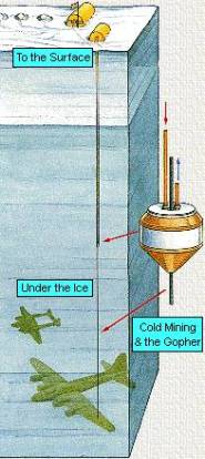
It was in this area, 17 miles off the east coast of Greenland, that Bob Cardin and other members of his squadron had to ditch their six P-38’s and two B-17’s when they ran out of gas in 1942 - the height of WWII. Many years later, in 1981, several members of this original squad decided to see if they could recover their aircraft. They flew back to the spot in Greenland where they thought they would find their planes buried under a few feet of snow. To their surprise, there was nothing there. Not even metal detectors found anything. After many years of searching, with better detection equipment, they finally found the airplanes in 1988 three miles from their original location and under approximately 260 feet of ice! They went on to actually recovered one of them (“Glacier Girl†– a P38), which was eventually restored to her former glory.20

What is most interesting about this story, at least for the purposes of this discussion, is the depth at which the planes were found (as well as the speed which the glacier moved). It took only 46 years to bury the planes in over 260 feet (~80 meters) of ice and move then some 3 miles from their original location. This translates into a little over 5 ½ feet (~1.7 meters) of ice or around 17 feet (~5 meters) of compact snow per year and about 100 meters of movement per year. In a telephone interview, Bob Cardin was asked how many layers of ice were above the recovered airplane. He responded by saying, “Oh, there were many hundreds of layers of ice above the airplane.†When told that each layer was supposed to represent one year of time, Bob said, “That is impossible! Each of those layers is a different warm spell – warm, cold, warm, cold, warm, cold.†21 Also, the planes did not sink in the ice over time as some have suggested. Their density was less than the ice or snow since they were not filled with the snow, but remained hollow. They were in fact buried by the annual snowfall over the course of almost 50 years.
Most scientists today believe that various places on this planet, such as Greenland, the Antarctic, and many other places, have some very old ice

Source: http://naturalselection.0catch.com/File ... ntice.html
 
He responded by saying, “Oh, there were many hundreds of layers of ice above the airplane.†When told that each layer was supposed to represent one year of time, Bob said, “That is impossible! Each of those layers is a different warm spell – warm, cold, warm, cold, warm, cold.â€Â
...which is explained by the irregular climate in this region. A few snow storms each year with periods of sunshine in between cause such a pattern.

This is not comparable to the vostok ice core at all. That region has 4.5mm (for comparison, death valley gets 50 mm, the sahara up to 75mm!) annual precipitation (averaging 30 years), of which 3.4mm (75.6%) occur in one half of the year in average (march to august). This stable 3:1 ratio of precipitation between two halves of a year results in recognizable layers.

http://www.coolantarctica.com/Antarctic ... cmurdo.htm
 
precipitation means snow as well. snow piles up and compresses lower snow into ice and layers follow.
 
And exactly these layers are being counted, yes.

Is there anything unreasonable about these being interpreted as annual layers (with an occasional exception perhaps, but nothing excessive)?

Would a change in the pattern of precipitation not be recognizable in the structure of the layers?
 
Back
Top